Burkina Faso
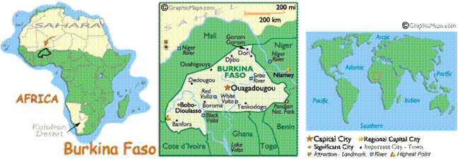
Burkina Faso, also known by its short-form name Burkina, is a landlocked nation in West Africa. It is surrounded by six countries: Mali, Niger,
Benin, Togo, Ghana
and Côte d'Ivoire.
Formerly called the Republic of Upper Volta,
it was renamed on August 4, 1984, to mean "the land of upright
people" in Moré and Dioula, the major native languages of the country.
Burkina Faso was populated early, between 12000 and
5000 BCE, and became a French Colony in 1896. In 1904, the largely pacified
territories of the Volta basin were integrated into the Upper Senegal and Niger colony of French West
Africa as part of the reorganization of the French West African
colonial empire. French Upper Volta was established on March 1, 1919. This move
was a result of French fears of the recurrence of armed uprising along with
economic considerations, and the colonial government separated the present territory of Burkina Faso
from Upper Senegal and Niger
to bolster its administration. The new colony was named Haute Volta. The colony
was later dismantled on September 5, 1932, being split up between the Côte d’Ivoire, French Sudan and Niger. Côte d'Ivoire
received the largest share, which contained most of the population as well as
the cities.
The decision was reversed during
the intense anti-colonial agitation that followed the end of World War II.
After World War II, on September 4, 1947, the colony was revived as a part of
the French Union, with its previous boundaries. On 11 December 1958, Upper Volta
became an autonomous republic in the French community. Full independence from France was
attained in 1960.
After gaining independence, the
country underwent many governmental changes until arriving at its current form,
a semi-presidential republic. The country occupies the seventh to last place on
the Human Development Index.